Photos

|
Cooke City, 2025-02-24 A rider triggered a small avalanche near Lulu Pass. No one was caught in the slide. Photo: N. Gaddy Link to Avalanche Details |

|
Cooke City, 2025-02-24 A rider triggered a small avalanche near Lulu Pass. No one was caught in the slide. Photo: N. Gaddy Link to Avalanche Details |

|
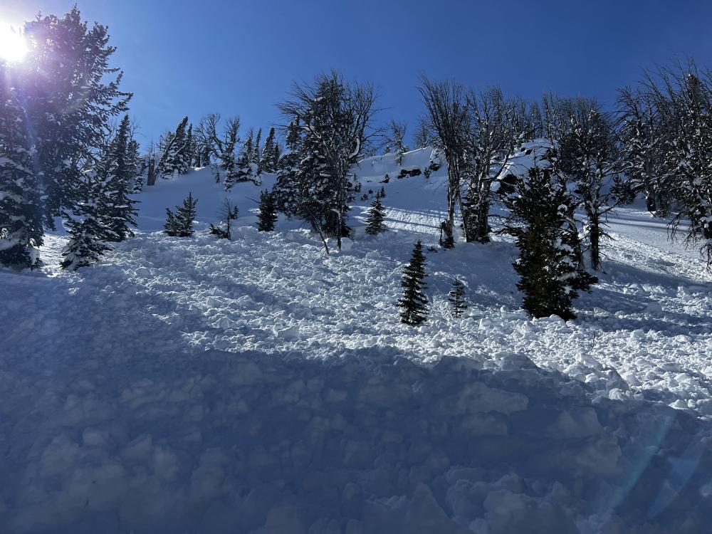
, 2025-02-24 A rider took a short ride in a wind slab Avalanche. Anonymous Link to Avalanche Details |

|
, 2025-02-24 A rider took a short ride in a wind slab Avalanche. Anonymous Link to Avalanche Details |

|
Cooke City, 2025-02-24 On Feb 23 We went up Republic Creek to look at the stability of snow that has fallen over the last 2-3 weeks. We were able to easily to trigger a couple wind slab avalanches on test slopes. Photo: GNFAC Link to Avalanche Details |

|
Cooke City, 2025-02-24 On Feb 23 We went up Republic Creek to look at the stability of snow that has fallen over the last 2-3 weeks. We were able to easily to trigger a couple wind slab avalanches on test slopes. Photo: GNFAC Link to Avalanche Details |

|
Cooke City, 2025-02-24 On Feb 23 We went up Republic Creek to look at the stability of snow that has fallen over the last 2-3 weeks. We found a thin layer buried 2’ deep that showed potential to propagate and slide. We dug down 4 feet, just below the dirt layer that was deposited earlier this month. We got an ECTP30 that broke about 8" above that dirt layer. This was either on a thin layer of facets or preserved lower density dendrites. Photo: GNFAC |

|
Southern Madison, 2025-02-23 Snowmobile triggered avalanche likely on Saturday, Feb 22. It appeared that no one was caught or buried. Link to Avalanche Details |

|
Southern Madison, 2025-02-23 Snowmobile triggered avalanche that resulted in a partial burial with no injuries on Friday, Feb 21. Link to Avalanche Details |

|
Southern Madison, 2025-02-23 Snowmobile triggered avalanche that resulted in a partial burial with no injuries on Friday, Feb 21. Link to Avalanche Details |

|
Southern Madison, 2025-02-23 From IG message: "We remotely triggered this hillside in Taylor's fork yesterday [2/21] from the Ridgeline above it. We were looking for a safe spot to drop down when it released below us. Circled around for some pictures. The snow was pretty shallow, only 2-3 feet deep, and slid to the ground. South facing slope" Link to Avalanche Details |

|
Bridger Range, 2025-02-23 From obs.: "Saw a recent cornice triggered wind slab off of Hardscrabble Peak, crown looked fairly fresh. There was a second crown line below the rock band. Conditions were very windy, with snow still being transported. Most snow surfaces were wind affected, but saw no cracking or collapsing." Photo: F. Miller Link to Avalanche Details |

|
Out of Advisory Area, 2025-02-23 From IG story. Link to Avalanche Details |

|
Southern Madison, 2025-02-22 There was a thin melt/freeze crust formed on solar aspects lower down (up to ~500 feet above the parking). Photo: BP |

|
Southern Madison, 2025-02-22 From email: "One of my crew was partially buried in an avalanche today(head about 1’ down, leg and arm still above snow) at approximately 13:10 hrs. Slope was greater than 35 degrees, crown approximately 85 yards wide, over 3’ at its thickest point. I believe it was a NE exposure with wind loading at the top. I had a bad feeling about this slope and mentioned it to my crew and avoided riding on it until one rider ran out of gas and I had to help him. Upon completion of task, I rode back to a spot that wasn’t as safe a vantage point as what I had previously stayed at, but the intention was we were all on our way out. So I parked and within 30 seconds, I hear my friend yelling behind me. I turn and immediately think “oh he’s about to hit us”. So, I attempted to start up my sled, to no avail While watching behind me. Suddenly, a massive “snow cloud” appeared about 30 yards above him and it took about 2-4 seconds to register that it was an avalanche and not another rider careening out of control at us. By that time, it was too late to do anything. The avalanche had reached the back of my friend and my sled, pushing us forward about 6 feet at 3-4mph. After it stopped, I assessed 3 of four of our team was accounted for, and one (the one who yelled at us) was not. He was partially buried by the front of the avalanche much like our sleds were. Fortunately, within 5 seconds, I saw an arm and a leg sticking out of the snow and we had his airway and head cleared within about 20 seconds. He was located approximately 10 yards from us. " Link to Avalanche Details |
|
Southern Madison, 2025-02-21 Snowmobile triggered avalanche in Teepee Basin. Link to Avalanche Details |

|
Southern Madison, 2025-02-21 Large cornice fall triggered avalanche in Sage Creek, Photo: GNFAC Link to Avalanche Details |