Snowpack and Avalanche Discussion
<p><span><span><span><span><span><span>There is simply a lot of snow and riding conditions are as good as it gets; however, remember that most avalanches happen within 24-48 hours after snowfall or wind.</span></span></span></span></span></span></p>
<p><span><span><span><strong><span><span>Wind slabs</span></span></strong></span></span></span><span><span><span><span><span><span> - In all areas, the primary avalanche problem is wind slabs as Dave found </span></span></span></span></span></span><a href="https://www.mtavalanche.com/node/34254"><span><span><span><span><span><… Island Park </span></span></u></span></span></span></span></span></a><span><span><span><span><span><span>and a skier found on </span></span></span></span></span></span><a href="https://www.mtavalanche.com/node/34251"><span><span><span><span><span><… Peak</span></span></u></span></span></span></span></span></a><span><span><span><span><span><span> yesterday where a wind slab broke 18 inches deep, 50 feet wide and ran a significant distance. Winds yesterday from the NW did most of the drifting, and winds shifting to the SW today may find a little snow to move. Fortunately there are many slopes unaffected by winds.</span></span></span></span></span></span></p>
<p><span><span><span><strong><span><span>Storm slabs</span></span></strong></span></span></span><span><span><span><span><span><span> - The new snow should be bonding to itself and stabilizing quickly, but there is just a lot of powder out there creating some uncertainty. Because there’s still a possibility of storm slabs, I’d select terrain with a clean runout today free of terrain traps, rocks, and trees if getting onto steeper slopes.</span></span></span></span></span></span></p>
<p><span><span><span><strong><span><span>Persistent slab avalanches</span></span></strong></span></span></span><span><span><span><span><span><span> - A problem in the Lionhead area, southern Madison Range (Taylor Fork, Teepee, Carrot, etc.) and southern Gallatin Range. The problem layer is small facets that formed in late January, now buried 2-3 feet deep. The Cooke City area may still have this problem, but it is buried deeper and seems to be less of an issue. A snowmobiler was caught in a </span></span></span></span></span></span><a href="https://www.mtavalanche.com/node/34154"><span><span><span><span><span><… persistent slab avalanche on Lionhead</span></span></u></span></span></span></span></span></a><span><span><span><span><span><span> on Thursday BEFORE all this snow fell. The most likely places to trigger one of these slides is on a slope with extra loading from yesterday’s winds, but I think there will still be slides on this layer on non-wind loaded slopes that will surprise you..</span></span></span></span></span></span></p>
<p><span><span><span><strong><span><span>Travel advice today</span></span></strong></span></span></span><span><span><span><span><span><span> - Stay off slopes or portions of slopes with fresh wind drifting. Consider the consequences of triggering a soft storm slab avalanches even though the likelihood of these slides is going down. If traveling in areas with a persistent slab avalanche problem, I’d simply avoid avalanche terrain for now and give the faceted layer time to stabilize. </span></span></span></span></span></span></p>
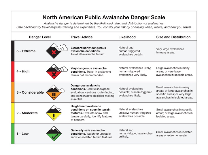
<p><span><span><span><span><span><span>The avalanche danger in all areas is CONSIDERABLE in places with fresh wind loading where you will trigger a slide.. The danger is MODERATE on all other slopes not loaded by recent winds</span></span></span></span></span></span></p>
Upcoming Avalanche Education and Events
Our education calendar is full of awareness lectures and field courses. Check it out: Events and Education Calendar