This is Alex Marienthal with the avalanche forecast for Monday, February 17th, at 7:00 a.m. sponsored by Upper Yellowstone Snowmobile Club, Bridger Bowl and Beartooth Powder Guides. This forecast does not apply to operating ski areas.
Snowfall totals since yesterday morning are:
- 5-11” (0.4-1.2” SWE) in the Bridger Range, Big Sky and Cooke City.
- 4-6” (0.3-0.5” SWE) in Hyalite, Taylor Fork, West Yellowstone and Island Park.
Temperatures are teens to 20s F this morning and will reach teens and 20s F today. Wind has been from the west and southwest at 10-20 mph with gusts of 20-40 mph. Today the wind will be light to moderate out of the west at 10-25 mph. Snowfall is forecast through tomorrow morning with 5-8” possible near Bozeman, Big Sky and Cooke City and 2-5” near West Yellowstone and Island Park.
A person can easily trigger avalanches that involve the recent snow. These will be largest and most likely where the snow has drifted into thicker slabs. On non-wind-loaded slopes large avalanches are possible, and more likely in areas with the most snow.
Since Friday the mountains near Bozeman and Big Sky received up to two feet of snow equal to 1.0-2.2” of snow water equivalent (SWE) with the highest amounts in the northern Bridgers. The last few days we received reports of wind slab avalanches (photo) where the snow had been drifted, and storm slab avalanches on slopes that were less wind-loaded (photo, photo). Loose dry avalanches are also likely and will be largest where the most snow fell.
Check out Dave’s video from Beehive yesterday for current insight on these avalanche problems. Expect these problems to grow in size and likelihood as more snow falls today.
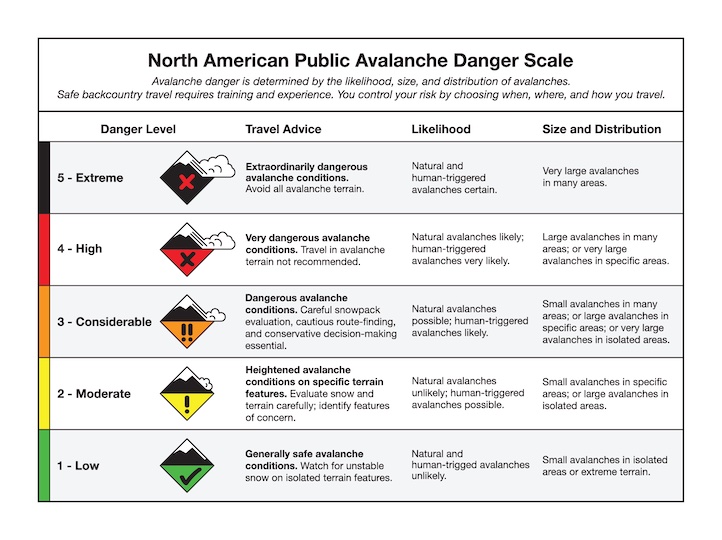
Plan to avoid wind-loaded slopes steeper than 30 degrees, and before crossing or riding other steep slopes carefully assess the stability of recent snow. Watch for cracking across the snow surface or recent avalanches as signs that the new snow is unstable. Consider smaller slopes that are sheltered from the wind and with minimal terrain traps like thick trees or cliffs, or avoid steep slopes altogether. The avalanche danger is CONSIDERABLE.
Near West Yellowstone, Island Park, and Cooke City received 1-1.5 feet of snow equal to 1.2-1.4” SWE since Friday. Similar to the northern parts of our forecast area, the primary concern is wind slab avalanches on slopes where the snow was drifted into thicker or stiffer slabs, and on non-wind-loaded slopes storm slab avalanches are possible. Over the weekend we received reports of these types of avalanches in Cooke City (photos and observation 1, observation 2). With the snow totals continuing to add up today, expect these types of avalanches to be larger and more widespread.
In these southern parts of our forecast area persistent slab avalanches could break on weak layers buried 2-3 feet deep. On Thursday in Taylor Fork Dave and I saw four avalanches that broke 1-2 feet deep on layers of sugary facets and feathery surface hoar. Yesterday we received a report from Lionhead of a rider triggered wind slab avalanche that triggered a deeper persistent slab avalanche (report). Avalanche activity on these layers hasn’t been widespread, but they should not be ignored (Lionhead photo, Cooke City photo, Taylor Fork video). As the new snow adds up the chance of triggering a larger persistent slab avalanche is increasing.
Avoid steep wind-loaded slopes, and before committing to any steep slope carefully assess the stability of recent snow and potential for buried weak layers. Avalanche danger is CONSIDERABLE on wind-loaded slopes and MODERATE on all others.
Special Note: With the abundance of recent snow, tree well immersion is a serious concern. Don’t ride too close to the base of trees, and keep continuous communication with your partners and know where they are even when not in avalanche terrain.
Upcoming Avalanche Education and Events
Our education calendar is full of awareness lectures and field courses. Check it out: Events and Education Calendar
February 18, 3-4 p.m. Whumpfs and anticracks: the science and mechanics of snow slab avalanches. A free advanced snow science presentation by a visiting professor from Germany at Montana State University in Roberts Hall, Room 101.
February 20, 4-7 p.m. Beacon BBQ at Uphill Pursuits in Bozeman. Come try out different brands of avalanche transceivers (or practice with your own!) with coaching from Friends of GNFAC instructors and free hotdogs.
February 28 - March 2, Bozeman Splitfest 2025 - Celebrate all things Bozeman backcountry and raise funds for GNFAC. Enjoy demos, clinics, free food and beer from MAP. Connect with fellow outdoor enthusiasts and soak up the winter stoke.
Every weekend in Cooke City: Friday at The Antlers at 7 p.m., Free Avalanche Awareness and Current Conditions talk, and Saturday from 10 a.m.-2 p.m. at Round Lake Warming Hut, Free Rescue Practice.