This is Dave Zinn with the avalanche forecast for Tuesday, February 18th, at 7:00 a.m. sponsored by World Boards and Polaris. This forecast does not apply to operating ski areas.
This morning, snowfall continues with temperatures in the single digits to teens F and 10-20 mph winds from the west through the north.
24-hour snowfall totals:
- Bridger, Northern Gallatin and Northern Madison Ranges - 8-12” (0.5-0.9” of snow water equivalent - SWE)
- Cooke City, West Yellowstone and Island Park - 4-6” (0.3-0.6” SWE)
Storm totals since Thursday night are impressive (weather log):
- Bridger Range - 36” of snow (3.1” SWE)
- Big Sky - 43” of snow (2.1” SWE)
- Gallatin Range, S. Madison Range, Cooke City, Island Park and West Yellowstone - 16-25” (1.5-1.9” SWE)
Today, snowfall will taper off in the middle of the day, but not before another 2-4” falls across the advisory area. High temperatures will be in the teens to low 20s F with 10-20 mph winds from the west and northwest.
All Regions
There has been a lot of snow recently, and dangerous avalanche conditions exist across the forecast area. Two things have kept us from going to an avalanche warning. First, snow has fallen with little wind. Second, we have a stronger-than-average snowpack this season (see Mark’s video). But make no mistake: if you ski or ride in steep terrain, you will likely trigger an avalanche (list of recent avalanche activity), and that avalanche will likely be large enough to carry, injure or kill you.
Across the forecast area, wind slab avalanches on steep wind-loaded slopes are sensitive to human triggers (you). Thankfully, without much wind so far (knock on wood), these unstable wind drifts will be in relatively predictable locations on higher elevation slopes, often above treeline, near ridgelines and below cornices. Avoid all steep slopes you think might be wind-loaded and be watching for signs of instability telling you to back off.
Careful snowpack assessment, cautious route-finding and conservative decision-making are essential to safer travel in non-wind-loaded terrain. During my fieldwork the last two days, I continually evaluated for shooting cracks, scanned hillsides for avalanche activity and dug down a couple of feet below the new snow to assess and test for instability related to buried weak layers (Beehive video). Evaluate the potential for storm slab avalanches resulting from inconsistencies within the recent snow and loose snow avalanches (or sluffs) on steep slopes where the new snow isn’t acting cohesively. Yesterday, skiers north of Bridger Bowl and in Cooke City did a great job recognizing instability and adjusting travel plans to match conditions (Ramp observation, Throne observation, Republic Creek observation). Even with good evaluation, instability can surprise you as it did with skiers in Hyalite and riders on Buck Ridge (Elephant Mountain photo, Buck photo).
Persistent slab avalanches could break on weak layers buried 2-4 feet deep in the Southern Gallatin and Southern Madison Ranges and the mountains around West Yellowstone, Cooke City and Island Park. Last week in Taylor Fork Alex and I saw four avalanches that broke 1-2 feet deep on layers of sugary facets and feathery surface hoar. This weekend, a rider triggered a small wind slab avalanche at Lionhead that subsequently triggered a deeper persistent slab avalanche (report). Continued snowfall and wind-loading increase the likelihood of these larger slides (Lionhead photo, Cooke City photo, Taylor Fork video). Test for instability on these buried weak layers before considering any steeper terrain.
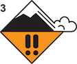
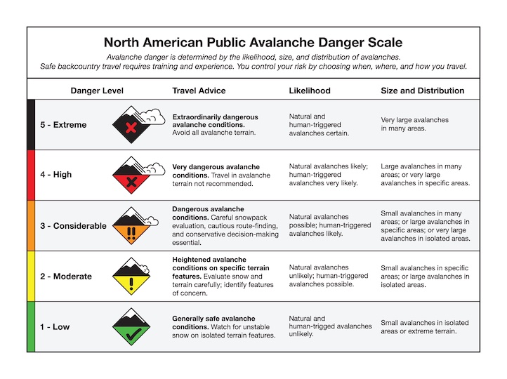
If you are unsure about the terrain and snowpack assessments described above, or they seem like too much work, avoid terrain steeper than 30 degrees because the danger is rated CONSIDERABLE on all slopes.
Special Note - Tree Wells
With the abundance of recent snow, tree well immersion is a serious concern. Don’t ride too close to the base of trees, and keep continuous communication with your partners and know where they are even when not in avalanche terrain.
Upcoming Avalanche Education and Events
Our education calendar is full of awareness lectures and field courses. Check it out: Events and Education Calendar
TODAY, February 18, 3-4 p.m. Whumpfs and anticracks: the science and mechanics of snow slab avalanches. A free advanced snow science presentation by a visiting professor from Germany at Montana State University in Roberts Hall, Room 101.
February 20, 4-7 p.m. Beacon BBQ at Uphill Pursuits in Bozeman. Come try out different brands of avalanche transceivers (or practice with your own!) with coaching from Friends of GNFAC instructors and free hotdogs.
February 28 - March 2, Bozeman Splitfest 2025 - Celebrate all things Bozeman backcountry and raise funds for GNFAC. Enjoy demos, clinics, free food and beer from MAP. Connect with fellow outdoor enthusiasts and soak up the winter stoke.
Every weekend in Cooke City: Friday at The Antlers at 7 p.m., Free Avalanche Awareness and Current Conditions talk, and Saturday from 10 a.m.-2 p.m. at Round Lake Warming Hut, Free Rescue Practice.